Tag: U.S. Forest Service

Prescribed Fire Planned on North Kaibab Ranger District

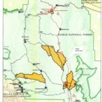
FREDONIA — Fire managers are expecting to conduct a prescribed fire operation on the North Kaibab Ranger District this week. The Telephone Hill Unit is located approximately 14 miles south of Jacob Lake adjacent to State Route 67, which has closed for the winter season. Fire Managers are focusing ignition around the Pleasant Valley Cabin area of the unit to reduce hazardous fuel loads around the cabin and State Route 67 corridor, the operation is expected to affect about 700 acres in that vicinity. Operations could begin as early as Tuesday, December 10, and are expected to be completed in 2-3 days, coinciding with prescribed fires planned on Grand Canyon National Park’s North Rim.

Blue Stem Prescribed Fire Complete, Rx Burns Continuing on Williams Ranger District This Week

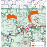
WILLIAMS — Fire managers have successfully treated 6904 acres on Tusayan Ranger District last week completing the Blue Stem Rx Fire Project and are moving back to the Three Sisters Prescribed Fire Project located just north of the City of Williams and Interstate 40, south of forest road 124, between Airport Road and the west side of Highway 64. 

Improving weather conditions have re-opened the opportunity for crews to return working in the local areas near Williams and Spring Valley. Plans are in place to begin ignitions on approximately 1500 acres of the Pronghorn and Cataract units of Three Sisters project on Tuesday October 8, and then move to the 4200 acre Marteen East Rx Fire Project later this same week. This project is located north of Spring Valley, west of forest road 144, and east of Laws Spring.

Burned Area Emergency Response team assessing Pipeline Fire damage

A Forest Service Burned Area Emergency Response (BAER) team has started surveying the fire-affected areas located within the Pipeline Fire perimeter.

BAER team assessments are rapid evaluations of post-fire conditions of the burned landscape. These assessments determine the level of risk from potential flooding and debris flow, and calculate how these risks will affect both human safety and the natural and cultural resources in the area.

The team, led by Forest Service Soil Scientist Eric Schroder, began conducting field surveys yesterday. In addition to field surveys, BAER teams use science-based models to rapidly evaluate and assess the burned area.