Tag: Pipeline Fire

Pipeline Fire closure to lift, allowing motor vehicle access in Schultz Pass area once again

FLAGSTAFF — Several roads located in the Schultz Pass area of the Coconino National Forest’s Flagstaff Ranger District will reopen to motorized vehicles tomorrow following a roughly two-year closure due to the Pipeline Fire.

The temporary trail and road closure order for the Pipeline Fire, which has been in effect since September of 2022, will be lifted at 8 a.m. Friday (Aug. 16).

Gates, barricades and signage posted in the area will be modified and removed to reflect the removal of the closure order.


Self-fill sandbag stations available in west Flagstaff for residents impacted by Pipeline Fire  

The City of Flagstaff has established two self-filling sandbag stations for those impacted by the Pipeline Fire who live on the west side of Flagstaff. The first station is in Thorpe Park, at the parking lot at the north end of N. Aztec St. between Frances Short Pond and the softball fields. The second station is located at the intersection of Schultz Pass Rd and E Mt Elden Lookout Rd. (commonly called the Schultz “Y”). Maps of these locations are attached.  

BAER team completes Soil Burn Severity map for Pipeline Fire

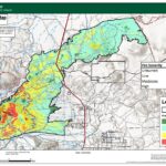
Forest Service Burned Area Emergency Response (BAER) specialists recently completed their field data evaluation to produce the Soil Burn Severity (SBS) map for the Pipeline Fire, which delineate unburned, low, moderate, and high SBS categories.

The BAER team assessing the Pipeline Fire determined that approximately 1,310 acres (1%) of the fire is unburned, approximately 15,004 acres (56%) have low soil burn severity, approximately 9,141 acres (34%) sustained a moderate SBS and approximately 1,315 acres (5%) were identified as having high SBS.

‘READY, SET, GO’ Status Changes for Elden Lookout Road, Doney Park South, and Alpine Ranchos East

After meeting with the Great Basin Type 1 team managing the Pipeline and Haywire Fires, it has been determined that it is safe to downgrade some areas on evacuation status.

The following changes will be effective immediately:

Pipeline Fire at 22,888 acres, 31% containment | Haywire Fire at 5,065 acres, 0% containment

The Type 1 Great Basin Incident Management Team (IMT) 2 has arrived at the Pipeline and Haywire fires, and is shadowing the Type 2 California Interagency IMT 15. The Type 1 team will assume command of the incident 6 a.m. Thursday.

The Pipeline Fire is currently 22,888 acres with 31% containment and the Haywire Fire is estimated at 5,065 acres with no containment.

While critical fire weather continues due to dry conditions and high temperatures, lower wind speeds allowed aerial operations to resume and continue throughout the day.

United Way of Northern Arizona — Once Again, Our Community Is Burning

For the past 12 years, the names have accumulated like a litany of destruction: Schultz. Slide. Tinder. Museum. Tunnel.

Now, less than two months after the last major wildfire left our mountains glowing red at night and our skies dark with smoke during the day, we have two more names to add to this sad list – Pipeline and Haywire.

The situation northeast of Flagstaff is still very fluid. The latest statistics from InciWeb (the US Forest Service site that tracks wildfires nationwide) indicate that 20,000 acres have burned in the Pipeline Fire with another 4,000 charred by Haywire.

Evacuation statuses have shifted back and forth as officials receive more information, but even those who were allowed to return to their homes Tuesday were warned to be ready to leave again at a moment’s notice. At this point, we know two structures have burned since Sunday.

Pipeline and Haywire Fires Update and Declaration of Emergency

The Pipeline Fire, located 6 miles north of Flagstaff, started Sunday, June 12, and has spread to over 5,000 acres due to extremely high winds.

Additionally, the Haywire Fire, located 8 miles northeast of Flagstaff, ignited in the early hours of Monday, June 13, and is currently at 1,600 acres in size. A U.S. Forest Service Type 2 Incident Management Team is currently on site for each fire. A Type 1 Incident Management Team has been ordered.

The Coconino County Sheriff’s Office has evacuated many communities in the fire area. Click here for the most current information on evacuation status:

https://coconinocounty.maps.arcgis.com/apps/MapSeries/index.html?appid=745e7806b 0444387bf32792b9c25e169

Closure of Buffalo Park, some City open spaces and FUTS entrances into the Coconino National Forest Temporary Area Closure due to Pipeline Fire

Buffalo Park and the Schultz Creek Natural Area are closed until further notice due to the Pipeline Fire. The Observatory Mesa Natural Area is also closed until further notice due to being surrounded by the Coconino National Forest Temporary Area Closure.

Flagstaff Urban Trail System (FUTS) entrances into the National Forest Temporary Area Closure are also closed. To view a map of the City of Flagstaff closures of FUTS entrances and open spaces, please visit https://flagstaff.maps.arcgis.com/apps/instant/sidebar/index.html?appid=f478005aa53048438453f3c7dc08155c